Delaware Source Water Protection Program

Skip to content
  • Home
  • DNREC
  • DHSS
  • DWRC
  • EPA
  • Resources
Delaware Source Water Protection Program

Mapping Resources

Department of Natural Resources & Environmental Control
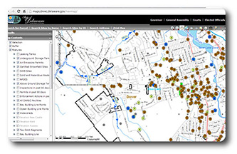
  • Delaware Environmental Navigator (DEN) – Use DEN to create maps showing Source Water Protection Areas. DEN also has wellhead protection and recharge area GIS layers for download.
  • Instructions for creating a map in DEN
  • On Thursday, December 6, 2007, the Delaware Cabinet Committee on State Planning Issues  dopted DNREC’s Statewide Wellhead Protection Areas and Statewide Excellent Recharge Areas as required under 7 Del. C 6083. To view the presentation click here.
  • Wellhead Protection Areas
  • Groundwater Recharge Areas
Institute for Public Administration’s Water Resources Agency
  • 2011 Water Resource Protection Area Mapping for New Castle County, Delaware
  • Delaware’s Floodplains – Floodplain Interactive Web Map

Delaware Environmental Monitoring and Analysis Center (DEMAC)

New Castle County, Delaware

  • New Castle County GIS Maps

Kent County, Delaware

  • GIS Mapping / 911 Addressing A Division of Planning Services

Sussex County, Delaware

  • Mapping and Addressing Department

Environmental Protection Agency (EPA)

  • Drinking Water Mapping Application to Protect Source Waters
  • 1998 Section 303(d) List Fact Sheet for Delaware
  • Surf Your Watershed
  • USGS National Water Information System

Information

  • Contact Information
  • CTAC Meetings
  • Advisory Committee
  • News and Events
  • Source Water Funding

Resources

  • Division of Water Submission Portal
  • Source Water Loan Fund
  • Source Water Assessments
  • Source Water Ordinances
  • Source Water Protection Plans
  • Publications
  • Mapping Resources
  • Conservation
  • Useful Links
Proudly powered by WordPress